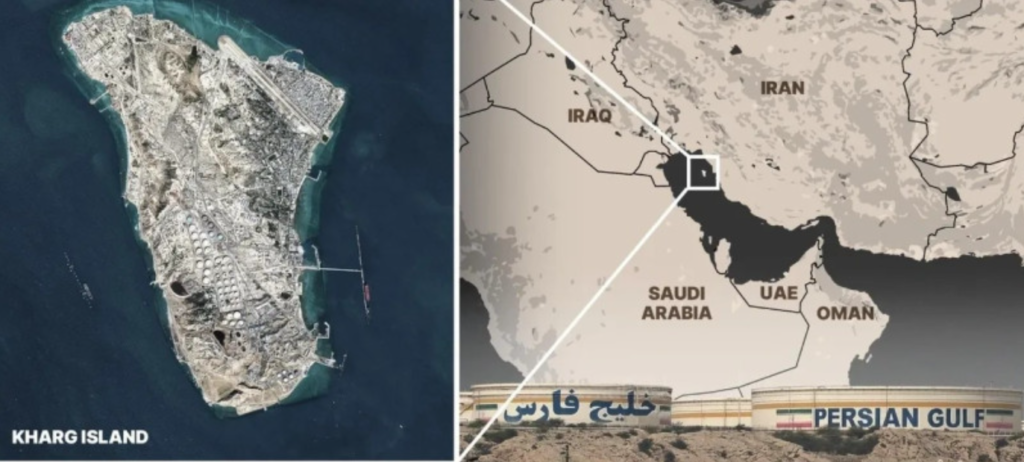
Kharg Island (Persian: جزیره خارگ), sometimes rendered as Khark Island and long nicknamed the “Forbidden Island,” stands as one of Iran’s most strategically vital landforms in the Persian Gulf. Situated roughly 25 kilometers (16 miles) off Iran’s southern coastline and about 660 kilometers (410 miles) northwest of the Strait of Hormuz, the island occupies a commanding maritime position. Administratively linked to Bushehr Province on the mainland, it functions as the beating heart of Iran’s oil export infrastructure. As much as 90 percent of the country’s petroleum exports flow through its terminals, while its vast storage facilities can hold up to 30 million barrels around five million cubic meters of crude oil at any given time.
Kharg’s significance is reinforced by its proximity to some of Iran’s key offshore oil fields, including Faridun, Darius, Cyrus, and Ardashir. Over the decades, this geographic advantage transformed the island into an indispensable energy hub. The city of Kharg, along with the Jazireh-ye Khark Lighthouse, anchors the island’s modest but critical urban presence. Despite its arid Gulf setting, Kharg benefits from its own freshwater resources an unusual and valuable feature in the region.
Yet the island’s story predates its oil-driven prominence. Before its rapid development into a major export terminal in the 1960s, the celebrated Iranian writer Jalal Al-e-Ahmad evocatively described it as “The Orphan Pearl of the Persian Gulf,” a poetic nod to its isolated beauty and quiet historical weight.
Beneath its modern industrial façade lies a layered past stretching back millennia. Kharg Island hosts significant archaeological remains, including the ruins of what is believed to be a Christian monastery dating as far back as the 7th century. Scattered across the island are ancient tombs and temple sites, alongside an Achaemenid-era cuneiform inscription carved between 550 and 330 BCE an enduring testament to Persia’s imperial reach.
For centuries, Kharg served as a crucial trading outpost in Gulf commerce. Its strategic location drew successive waves of foreign control: the Portuguese Empire held sway over the island from the 16th to the 17th centuries, followed by Dutch colonial influence in the 18th century. Each left traces of their presence, embedding the island deeper into the maritime and mercantile history of the region.
Today, Kharg Island stands at the intersection of antiquity and geopolitics an ancient crossroads reborn as one of the world’s most consequential energy gateways.
The earliest known visual representations of the island date back to the great age of European maritime exploration. In the 16th century, renowned Portuguese cartographers Fernão Vaz Dourado, Lopo Homem, and Diogo Homem etched the island into their meticulously detailed nautical charts, marking it as a notable waypoint in the Persian Gulf’s intricate web of trade routes. These early maps, crafted at a time when Portugal sought to dominate Indian Ocean commerce, testify to the island’s long-recognized strategic and commercial value.
Centuries later, the island’s modern transformation began under the rule of Mohammad Reza Pahlavi. During the 1960s, amid Iran’s ambitious drive to modernize and expand its energy sector, it was systematically developed into a major oil export terminal. This evolution was undertaken in collaboration with the American oil company Amoco, reflecting Tehran’s close ties with Western energy firms at the time. Infrastructure rapidly expanded, turning the once relatively quiet Gulf outpost into a linchpin of Iran’s petroleum industry and a critical artery for global oil markets.
In more recent history, the island once again found itself at the center of conflict. In March 2026, during the Iran war, United States forces carried out airstrikes targeting military installations on the island. The bombardment underscored its enduring strategic importance not only as an energy hub but also as a site of military significance in a region shaped by shifting alliances and geopolitical rivalries.
Name of the Island
Over the centuries, the island’s name has evolved in tandem with the shifting currents of language, empire, and cartography that have shaped its history. Influenced by regional dialects as well as the interpretations of European mapmakers, its designation has appeared in multiple forms across historical records. Variations such as Kharg, Khark, Kharaj, and Kharej reflect the fluid interplay between Persian pronunciation and the transliterations adopted by foreign navigators and chroniclers. Each spelling captures a moment in time an echo of how traders, explorers, and local inhabitants alike identified this strategically significant outpost in the Persian Gulf.
Geography and governance control
Kharg Island rises from the Persian Gulf as a rugged coral outcrop, positioned roughly 25 to 28 kilometers off Iran’s southern coastline and about 55 kilometers northwest of the port city of Bushehr. Farther along the Gulf’s strategic arc, it lies approximately 660 kilometers northwest of the Strait of Hormuz, placing it at a critical junction of maritime energy routes. Modest in scale yet immense in significance, the island stretches about eight kilometers in length and spans between four and five kilometers at its widest point.
The surrounding waters are notably deep, a geographic advantage that has long enhanced the island’s value as a maritime and industrial hub. Unlike many Gulf islands, which depend heavily on external water supplies, Kharg possesses its own freshwater resources—an uncommon and strategically important feature in the arid region. Beneath the sea surface nearby lie several major offshore oil fields, including Faridun, Darius, Cyrus, and Ardashir. Subsea pipelines extend from these fields directly to the island, reinforcing its central role in Iran’s petroleum infrastructure.
At the heart of the island stands the city of Kharg, the sole urban settlement within the Kharg District. Administratively, the island falls under the jurisdiction of Bushehr Province on the mainland. Entry to Kharg has traditionally been tightly controlled due to its strategic and industrial importance. Guarded by Iran’s Islamic Revolutionary Guard Corps (IRGC), it has earned the enduring nickname “the Forbidden Island,” a reflection of both its restricted status and its sensitive energy installations.
In recent years, however, authorities have begun cautiously exploring the island’s tourism potential. Since the 2010s, discussions have centered on how to balance controlled access with preservation and security concerns. In 2026, the government introduced a special category of visitor permit aimed at opening limited pathways for tourism. Under this framework, prospective visitors must submit detailed applications outlining the purpose and itinerary of their trip. Approved travelers are required to be accompanied at all times by an authorized guide, ensuring that access remains carefully supervised even as the island tentatively broadens its engagement with the outside world.
History of Kharg Island
Middle Ages
During the Middle Ages, Kharg Island emerged as a small yet vibrant node in the commercial and cultural networks of the Persian Gulf. Its name appears in the Hudud al-‘Alam, a 10th-century geographical compendium written around 982 CE, where it is praised as a productive center for pearl harvesting. At a time when Gulf pearls were prized across distant courts and markets, such recognition underscored the island’s integration into lucrative maritime trade circuits.
The noted geographer Abu Esḥāq Eṣṭaḵri regarded Kharg as belonging to the district of Ardašir-ḵorra, situating it administratively within the broader Persian territorial framework of the era. Beyond its bureaucratic classification, however, the island’s true importance lay in its function as a maritime waypoint. Merchant vessels navigating between the Indian subcontinent and the bustling southern port of Basra frequently paused at Kharg, using it as a strategic stopover for resupply, trade, and shelter along the sea lanes that connected South Asia with the heart of the Abbasid world.
In 1218, the distinguished geographer and bibliographer Šehāb-al-Din Abu ʿAbd-Allāh Yāqut visited the island, further cementing its place in the geographic imagination of the medieval Islamic world. His accounts, alongside earlier references, reveal an island that was far from isolated; rather, it was embedded in the intellectual and commercial currents of its time.
Kharg’s medieval economy rested on more than pearls and maritime exchange. The island’s inhabitants also cultivated fruit and tended groves of date palms, drawing sustenance and modest prosperity from agriculture adapted to the Gulf’s challenging climate. These orchards and plantations complemented its seaborne trade, creating a diversified local economy that blended maritime enterprise with agrarian resilience.
In the Middle Ages, then, Kharg was not merely a remote outcrop in the Persian Gulf but a dynamic participant in the region’s interconnected world—its shores touched by traders, scholars, and seafarers whose routes spanned from India to Mesopotamia.
Early modern era
During the era of European colonial expansion, the Portuguese emerged as the first foreign power to assert dominion over the island, along with other strategically positioned islands in the Persian Gulf, under the leadership of commanders Afonso de Albuquerque and Tristão da Cunha in 1507. Recognizing the critical importance of the Strait of Hormuz for trade and military strategy, the Portuguese established it as a vassal outpost, controlling access and serving as a key hub in their Asian trade network until 1622. To solidify their dominance and defend against both Persian forces and competing European powers, they constructed a fortress—later known as the Portuguese Castle—on the island, serving as a formidable military bastion.
By 1645, the island came to the attention of the Dutch, who, during a passing fleet voyage, christened it “Delft,” in homage to one of the offices of the Dutch East India Company. Two decades later, in 1665, the French traveler Jean de Thévenot visited Kharg and documented its active trade connections, noting commerce with prominent cities such as Isfahan and Basra.
Throughout the 18th century, Kharg gained a reputation as the premier location for hiring skilled pilots to navigate ships bound for Basra. However, the island was not immune to regional conflicts: in 1751, it suffered a raid by Ḥuwala Arabs. Two years later, in 1753, the Dutch East India Company solidified its influence when agent Baron Tiddo Frederik van Kniphausen negotiated a payment of 2,000 rupees to Mir Nasáir, the Arab ruler of Bandar Rig, securing perpetual rights to the island. Under Dutch administration, Kharg was transformed into a free port open to merchants of all nationalities. Kniphausen oversaw the construction of residential buildings in the northeast, while the Dutch established Fort Mosselstein and a trading post, using the island as a crucial station in their expansive colonial trading network.
In 1757, Kharg Island witnessed the construction of a church, marking a significant moment for the Persian Catholic community. A Carmelite priest was assigned to minister to what had become the largest Catholic congregation in Persia, prompting the Bishop of Isfahan to relocate his seat from Isfahan to Kharg, underscoring the island’s emerging religious prominence. However, the island’s colonial stability was short-lived. By January 1766, escalating tensions between the Dutch and the local population culminated in a decisive confrontation: Mir Muhanna, the governor of Bandar Rig, seized control of the fortress, effectively expelling the Dutch from Kharg permanently and ending their two-century-long influence in the region.
The strategic importance of Kharg continued into the 19th century. In 1837, British forces temporarily occupied the island as part of their efforts to prevent the Siege of Herat, though they soon relinquished control back to the local authorities. The island remained largely neglected by the Persians until the outbreak of the Anglo-Persian War in 1856, when British forces once again took possession of Kharg in December of that year. By the turn of the 20th century, the island’s population was nominally under the authority of the Hayat-Dawudi rulers, whose seat of power was established in Bandar Rig, maintaining a loose but recognized governance over the island and its inhabitants.
20th century
Under the reign of Reza Shah Pahlavi, Kharg Island was transformed into a place of exile for political dissidents, a measure that effectively curtailed any significant development and left the island largely isolated from broader economic or infrastructural initiatives. This period of restricted activity persisted until the mid-20th century, when the discovery and exploitation of Iran’s oil resources brought Kharg back into strategic prominence.
In 1956, construction began on a series of oil storage reservoirs on the island, designed to accommodate crude oil transported via pipeline from the Gachsaran oil field. Just three years later, in 1959, a major pipeline stretching 159 kilometers (99 miles) with diameters of 660, 710, and 760 millimeters (26, 28, and 30 inches) was completed. This terminal was capable of handling tankers of up to 100,000 deadweight tons (DWT) and was officially inaugurated on 8 November 1960, marking the beginning of Kharg’s transformation into a cornerstone of global oil logistics.
The expansion continued rapidly: by 1964, a 27-mile 30-inch submarine pipeline loop connected Bandar Ganaveh to Kharg, and with the installation of additional pumping stations along the onshore segment, the pipeline’s capacity rose from 330,000 barrels per day to 500,000 barrels per day. The following year, a 106-mile 42-inch line from the Aghajari oil field to Ganaveh was completed, accompanied by two more 27-mile submarine loops. These developments collectively established Kharg as the world’s largest oil shipment terminal at the time, cementing its reputation as a critical hub in the global energy network.
The island’s unique character did not go unnoticed. During a visit in 1960, the celebrated Iranian writer Jalal Al-e-Ahmad referred to Kharg as “the orphan pearl of the Persian Gulf,” a poetic acknowledgment of its isolated beauty amid a rapidly industrializing environment. Concurrently, Iran negotiated with Saudi Arabia over the delineation of their respective continental shelf boundaries in the Persian Gulf. The resulting compromise, a modified equidistant line, ensured that Kharg remained under Iranian sovereignty, preserving its strategic and economic importance.
By 1969, under the ambitious modernization programs of the Shah, Kharg was fully developed into a sophisticated oil terminal through a partnership between the National Iranian Oil Company (NIOC) and the American multinational Amoco. By the mid-1970s, the island hosted three major oil terminals: the Kharg Terminal, featuring a long T-shaped jetty on the east coast; the Sea Island Terminal off the western shore; and the Darius Terminal in the south. Additionally, the Kharg Chemical Complex, known as Khemco, functioned as a specialized gas terminal. With these expansive facilities, Kharg Island had grown into the largest offshore crude oil terminal in the world and the primary maritime outlet for Iran’s oil exports, symbolizing the country’s central role in the global energy landscape.
Iranian Revolution
The Iranian Revolution of 1979 marked a profound turning point for Kharg Island, particularly in its role within the global oil industry. Following the upheaval, the National Iranian Oil Company (NIOC) expropriated Amoco’s holdings on the island, effectively bringing all of the company’s oil infrastructure under Iranian state control. This move reflected the revolutionary government’s broader strategy of asserting sovereignty over national resources and reducing dependence on foreign corporations. In the decades that followed, despite enduring international sanctions, Iran continued to invest in Kharg’s infrastructure, expanding and modernizing the island’s facilities to enhance self-sufficiency and ensure that its oil exports could be managed independently without reliance on neighboring countries’ transit routes.
The strategic importance of Kharg made it a target during the devastating Iran–Iraq War of the 1980s. Between 1982 and 1986, the Iraqi Air Force launched repeated aerial bombardments against the island, inflicting severe damage on its oil terminals and associated infrastructure. The attacks temporarily crippled Kharg’s operations, slowing production and disrupting the flow of crude oil. In the war’s aftermath, reconstruction was slow but deliberate, with postwar efforts not only restoring the damaged facilities but also expanding and modernizing them to accommodate larger shipments and incorporate technological advancements, reinforcing Kharg’s status as Iran’s premier oil export hub.
In 1990, as part of a resolution to the post-revolution expropriation disputes, the Iranian government agreed to compensate Amoco with a payment totaling $600 million. This settlement included $540 million for the takeover of four Gulf drilling fields along with the Kharg oil terminal, and an additional $60 million for the island’s petrochemical processing plant. This agreement not only provided financial closure but also underscored Kharg’s enduring value and centrality in the geopolitics of energy, illustrating how the island had evolved from a remote outpost into a critical linchpin of Iran’s oil infrastructure.
21st century
In the early years of the 21st century, Kharg Island continued to solidify its role as the cornerstone of the Islamic Republic of Iran’s crude oil export infrastructure. By 2009, the island’s sprawling oil terminal complex was responsible for the movement through both exports and swaps of an estimated 950 million barrels of crude oil, underscoring its centrality to Tehran’s energy strategy and revenue streams.
Throughout the following decade, the National Iranian Oil Company (NIOC) maintained operational control of Kharg’s facilities, managing the terminals and associated maritime logistics amid a shifting geopolitical landscape marked by periodic sanctions and fluctuating export patterns.
As the world entered the 2020s, Kharg’s significance only deepened. Terminal infrastructure originally designed in the 1960s had been expanded and upgraded, giving the island loading capacities that, on paper, could handle millions of barrels per day. In practice, thousands of massive tankers mainly bound for Asian markets continued to load crude even as Iran navigated sanctions, market pressures, and periodic disruptions to global shipping in the Persian Gulf.
By the mid‑2020s, Kharg had become not just a vital export point but a strategic economic linchpin for Iran handling roughly 90% of the country’s seaborne crude exports and directly connecting the vast inland oil fields of southern Iran to the global marketplace.
Even during times of heightened tension in the region, including military escalations that targeted parts of Iranian infrastructure, oil export operations from Kharg continued with surprising resilience. Satellite imagery and tanker tracking data from 2026 show multiple very large crude carriers (VLCCs) at the island’s berths, and ongoing loading activity despite broader regional instability.
This continuity reflects both the institutional importance of Kharg to Iran’s economy and the technical adaptability of the terminals that have been continually modified since the mid‑20th century. The island’s deep‑water ports, extensive pipeline connections, and vast storage tank farms — delivered by decades of strategic investment remain vital not only to Tehran’s fiscal health but also to broader dynamics in the global oil market.
In short, Kharg Island in the 21st century has evolved from a remote Persian Gulf outpost into one of the most consequential nodes in the architecture of global energy exports — a place where geopolitics and hydrocarbon commerce intersect with enduring force.
- Kharg Island | Geography, Historical and Importance of Iran
- South China Sea
- Busay Falls in Villanueva, Calubian, Leyte
Mansour, Mohammad (11 March 2026). “The ‘orphan pearl’: Inside Kharg, the beating heart of Iran’s oil empire”. Al Jazeera. Archived from the original on 11 March 2026. Retrieved 14 March 2026.
Clark, Emily (11 March 2026). “Kharg Island could be Iran’s weak spot as Washington reportedly considers ground invasion options”. ABC News. Archived from the original on 12 March 2026. Retrieved 12 March 2026.
“Why Kharg Island matters: Iran’s strategic Gulf oil island”. The New Arab. 11 March 2026. Archived from the original on 12 March 2026. Retrieved 12 March 2026.
Mirfendereski, Guive (15 September 2015). “Kharg Island iii. Developments since the 1950s”. Encyclopaedia Iranica. Retrieved 15 March 2026.
Census of the Islamic Republic of Iran, 1395 (2016): Bushehr Province. amar.org.ir (Report) (in Persian). The Statistical Center of Iran. Archived from the original on 3 August 2017. Retrieved 19 December 2022.
Emery, Christian (13 March 2026), Phelps, Sam (ed.), “Kharg Island: Iran’s energy lifeline that has so far escaped attack”, The Conversation, doi:10.64628/ab.pr7vuxx9f, archived from the original on 14 March 2026, retrieved 14 March 2026
“Kharg Island Tourism: Permits & Access for Foreign Nationals [2026]”. Melste. 14 March 2026. Retrieved 15 March 2026.
Potts, D. T. (16 September 2015). “KHARG ISLAND II – History and archeology”. In Yarshater, Ehsan (ed.). Encyclopædia Iranica (Online ed.). Encyclopædia Iranica Foundation. PublishedJuly 20, 2004; last updated September 16, 2015
Tazmini, Ghoncheh (2018). “The Persian-Portuguese Encounter in Hormuz”. Cambridge University Press. doi:10.1080/00210862.2016.1263542.
Tazmini, Ghoncheh (2017). “The Persian-Portuguese Encounter in Hormuz”. Taylor and Francis. doi:10.1080/00210862.2016.1263542.
J. R. Perry, “The Banu Ka’b: An amphibious brigand state in Khuzistan”, Le monde iranien et l’Islam, 1, 1971, p. 131-152. Idem, “Mir Muhanna and the Dutch: Patterns of piracy in the Persian Gulf”, Stud. Ir. 2, 1973, p. 85.
“World Petroleum Report – Iran”. World Petroleum. Vol. 6. 15 February 1960. p. 78.
“Pipelines Around the World”. World Petroleum. Vol. 31, no. 11. October 1960. p. 65.
“World Petroleum Report – Iran – Transportation”. World Petroleum. Vol. 7. 15 February 1961. p. 222.
Minerals Yearbook 1963 Vol 4 Area Reports: International. U.S. Department of the Interior, Bureau of Mines. 1963. p. 1180.
Minerals Yearbook 1964 Vol 4 Area Reports: International. U.S. Department of the Interior, Bureau of Mines. 1964. p. 1043.
Minerals Yearbook 1965 Vol 4 Area Reports: International. U.S. Department of the Interior, Bureau of Mines. 1965. p. 999.
Minerals Yearbook 1965 Vol 4 Area Reports: International. U.S. Department of the Interior, Bureau of Mines. 1965. p. 981.
Waldia, Manisha (14 March 2026). “Which Island is Known as the ‘Orphan of the Pearl’?”. Jagranjosh.com. Retrieved 14 March 2026.
Kapoor, Srishti (14 March 2026). “”Orphan Pearl” On Fire: The Critical Oil Island Struck By US In Iran”. NDTV. Retrieved 14 March 2026.
“Khark Oil Exports”. Iran Daily. 2009. Archived from the original on 22 May 2009. Retrieved 3 March 2011.
Bou, Jordi (15 March 2026). “CONFLICT: Iran’s Kharg Island infographic”. Graphic News. Retrieved 15 March 2026.
“Iranian Accord With Amoco Lifts a Barrier to U.S. Trade”. The New York Times. 16 June 1990. Retrieved 15 March 2026.
Yoon, John (14 March 2026). “What to Know About Iran’s Kharg Island”. The New York Times. Retrieved 14 March 2026.
“Kharg Island: Iran’s Oil Backbone & Greatest Vulnerability EXPLAINER: Why Kharg Island is the backbone of Iran’s oil economy – and its greatest vulnerability”. www.kpler.com. 16 March 2026.
Paraskova, Tsvetana (26 February 2026). “Iran Rushes to Ship Oil Ahead of Possible U.S. Strike”. OilPrice.com.
“Der Iran räumt seit Wochen heimlich sein wichtigstes Öllager”. wiwo.de. 2026. Retrieved 10 March 2026.
“Trump Says U.S. Bombs ‘Obliterated’ Military Targets on Kharg Island”. The Wall Street Journal. Retrieved 13 March 2026.
Cooper, Helene; Stack, Liam (13 March 2026). “U.S. Attacks Iran’s Kharg Island, a Key Port for Oil Exporting, Trump Says”. The New York Times. ISSN 0362-4331. Retrieved 14 March 2026.
“US embassy in Baghdad hit by strike as Trump says military targets ‘obliterated’ on Iran’s key oil island – follow live”. BBC News. 14 March 2026. Retrieved 14 March 2026.
“US strikes more than 90 Iranian military targets on Kharg Island, CENTCOM says”. Reuters. 14 March 2026.
Barak Ravid, Marc Caputo (20 March 2026). “Trump mulls risky Kharg Island takeover to force Iran to open strait”. Axios. Retrieved 20 March 2026.
“Khark island’s Achaemenid inscription seriously damaged”. Payvand News. 1 June 2008. Archived from the original on 28 April 2012. Source: Mehr News Agency
“Newly Found Old-Persian Cuneiform Inscription of Kharg Island Deciphered”. Iranian Cultural Heritage News Agency. 8 December 2007. Archived from the original on 29 September 2011. Retrieved 3 March 2011.
“Kharg Island Achaemenid Inscription”. Persian Empire. Archived from the original on 15 November 2025. Retrieved 14 March 2026.
Borjian, Habib (2019). “The Language of the Kharg Island”. Journal of the Royal Asiatic Society. 29 (4): 680. doi:10.1017/S1356186319000403. S2CID 213053987.
Stiffe, Captain A. W. (1898). “Persian Gulf notes. Kharag Island”. Geographical Journal. 12: 179–182.
Sykes, P. M. (1915). A History of Persia. vol. 2. London.
Sarre, F.; Herzfeld, E. (1910). Iranische Felsreliefs (in German). Berlin. OCLC 5455552.
Steve, M.-J. (1999). “Sur l’île de Khârg dans le golfe Persique”. Dossiers d’Archéologie (in French). 243: 74–80.
Steve, M.-J.; et al. (2003). L’île de Kharg. Une page de l’histoire du Golfe Persique et du monachisme oriental. Civilisations du Proche-Orient (in French). Vol. Série I. Gent. ISBN 2-940032-03-3.
Haerinck, E. (1975). “Quelques monuments funéraires de l’île de Kharg dans le Golfe Persique”. Iranica Antiqua (in French). 11: 144–167.
Haerinck, E. (1998). “More pre-Islamic coins from southeastern Arabia”. Arabian Archaeology and Epigraphy. 9: 278–301. doi:10.1111/j.1600-0471.1998.tb00123.x.
Handbuch des Persischen Golfs (in German) (5th ed.). Hamburg: Deutsches Hydrographisches Institut. 1976.
Regan, Helen; Sharman, Laura (14 March 2026). “What to know about Kharg Island, the tiny coral outcrop at the heart of Iran’s oil industry”. CNN. Retrieved 14 March 2026.
“Kharg Airport”. SKYbrary Aviation Safety. Archived from the original on 15 October 2025. Retrieved 14 March 2026.
Huggins, John (1 June 2006). “Jazireh-ye Khark Light”. ARLHS IRA-002. Archived from the original on 13 August 2025. Retrieved 13 March 2026.
Rowlett, Russ. “Lighthouses of Iran”. The Lighthouse Directory. University of North Carolina at Chapel Hill. Retrieved 3 October 2016.
NGA List of Lights – Pub.112 Archived 3 October 2018 at the Wayback Machine Retrieved 3 October 2016
“Battlefield 3 Maps”. Electronic Arts. 2011. Archived from the original on 15 October 2011. Retrieved 15 October 2011.
“Delta Force: Black Hawk Down”. ModDB. 20 January 2004. Retrieved 16 March 2026.