Central Pressure Plunges to 896 mbar as 180+ mph Winds Threaten Saipan, Tinian, and Guam “Typhoon Alley” Braces for Possible Catastrophic Impact.
In just 24 hours, Sinlaku has transformed into a monstrous Category 5 system, packing sustained winds of up to 155 knots (180 mph) and an exceptionally low central pressure of 896 millibars with satellite data suggesting it could be even stronger. Forecast models place the storm on a dangerous path through the heart of Typhoon Alley, threatening Saipan, Tinian, and possibly Guam with life-threatening winds, destructive storm surge, torrential rainfall, and widespread infrastructure damage.
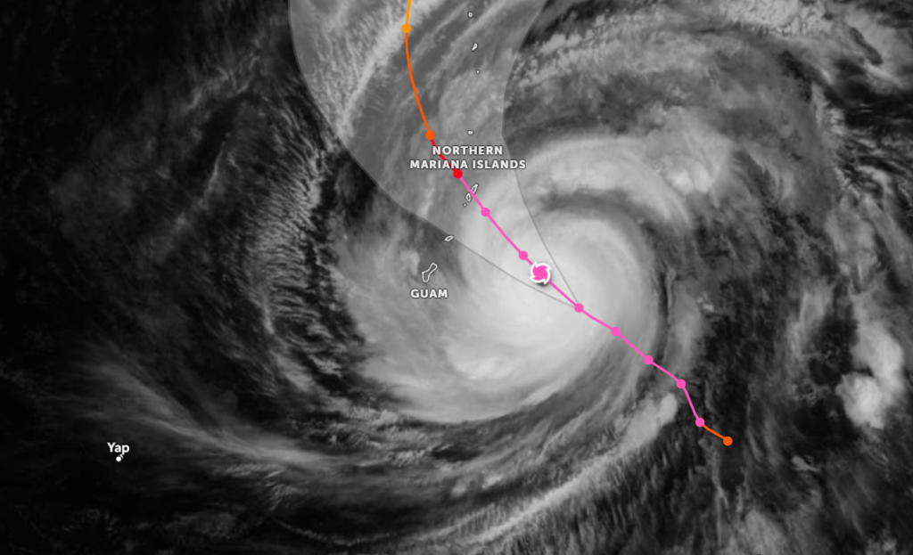
Guam — The present moment feels like a suspended breath a fragile hush hanging over the island before the fury of a gathering tempest. Across the vast expanse of the Philippine Sea, Super Typhoon Sinlaku is roaring westward, its massive circulation tightening with alarming speed. Forecast tracks now place both Guam and the Northern Mariana Islands squarely within its path, casting a long shadow over communities that know too well what it means to live in the Pacific’s notorious “Typhoon Alley.” Once again, the archipelago stands at the frontline of nature’s most formidable theater.
- Category 5 Super Typhoon Sinlaku Explosively Intensifies, Guam and Northern Marianas in Potential Direct Path
- Bagyong Basyang, Magdadala ng Matinding Ulan at Landslide sa Mindanao
Over the past 24 hours, Sinlaku has undergone explosive rapid intensification, dramatically exceeding earlier projections and evolving into the most powerful tropical cyclone on Earth so far in 2026. What began as a developing disturbance has transformed into a sprawling, symmetrical giant its cloud tops colder, its eye clearer, and its structure more consolidated with each satellite pass. Early Monday morning imagery captured a near-perfect storm: a sharply defined eye encircled by a dense, towering eyewall the unmistakable signature of an extremely dangerous typhoon at peak strength.
Now classified as a Category 5 super typhoon, Sinlaku is sustaining winds of up to 155 knots (180 mph), with a central pressure that has plunged to 896 millibars a staggering indicator of its intensity. In the world of meteorology, numbers at this scale are not just statistics; they are warnings etched in wind and water. Further satellite-based Advanced Dvorak analyses suggest the storm may be even stronger than initial estimates, potentially packing winds of 164 knots and a central pressure near 888 millibars. Lightning bursts flaring within the eyewall signal that Sinlaku continues to feed off deep oceanic heat, still strengthening as it advances.
The rapid drop in central pressure underscores the enormous reservoir of energy fueling the cyclone. Unseasonably warm April sea surface temperatures in the western Pacific have acted as high-octane fuel, allowing the storm to intensify at a pace that has unsettled even seasoned forecasters. Meteorologists warn that such environmental conditions can sustain extreme intensity right up to landfall a scenario that heightens the threat to vulnerable island communities.
While Guam remains under close surveillance, the latest forecast adjustments have shifted the projected core of the most violent impact toward the Northern Mariana Islands. Current models indicate the eyewall could pass directly over Saipan and Tinian, delivering winds equivalent to a high-end Category 4 or potentially Category 5 landfall. Storm surge, torrential rainfall, and destructive gusts could combine in a catastrophic trifecta, threatening infrastructure, power grids, and coastal communities already hardened by past disasters.
Yet Guam cannot afford complacency. Even if spared a direct eyewall strike, the island is likely to endure punishing outer bands capable of producing damaging winds, flash flooding, and life-threatening surf. In Typhoon Alley, small shifts in track can spell the difference between a glancing blow and a historic catastrophe.
The phrase “Typhoon Alley” is not hyperbole for Guam; it is geography and lived experience. Situated along one of the most active tropical cyclone corridors on Earth, the island has endured generations of storms that have reshaped its skyline and hardened its resilience. From catastrophic winds that flattened homes decades ago to more recent super typhoons that tested modern building codes and emergency systems, each storm has left a lasting imprint — lessons written in concrete, steel, and strengthened preparedness protocols.
To understand the gravity of Sinlaku’s approach is to remember those benchmarks of destruction the storms that forced Guam to rethink construction standards, reinforce power infrastructure, and refine evacuation strategies. Every satellite update now carries not just meteorological data, but the weight of history. Residents secure rooftops, stock emergency supplies, and review evacuation plans, drawing on collective memory shaped by past tempests.
As the skies remain deceptively calm and the trade winds whisper through palm trees, Guam waits. The ocean, however, tells a different story swells building, pressure falling, clouds thickening on the horizon. Whether Sinlaku ultimately delivers a glancing blow or a direct assault, its rapid intensification stands as a stark reminder of a warming ocean’s potential to breed extreme storms with breathtaking speed.
For now, it is the quiet before impact a moment of vigilance, preparation, and resolve. In the vast Pacific, where nature’s forces gather unchecked, the people of Guam and the Northern Marianas brace themselves once more, standing resilient at the edge of the storm.
From Devastation to Resilience: How Historic Super Typhoons Transformed Guam into a Concrete Stronghold
In recent decades, the Marianas have endured a series of powerful and historic typhoons among them Karen, Paka, and Pongsona each leaving a lasting imprint on Guam’s landscape and resilience.
Super Typhoon Karen in 1962 marked a defining turning point. Before Karen, the vast majority of homes on Guam were built of wood. But with maximum sustained winds reaching 185 mph, Karen devastated the island, destroying approximately 95 percent of all homes. The scale of destruction fundamentally reshaped Guam’s approach to construction. From that devastation emerged modern concrete building standards, transforming Guam into what is now often called a “concrete island.” Karen remains the benchmark storm against which all others are measured.
Typhoon Paka followed in 1997 with extraordinary force. A legendary wind gust of 236 mph was recorded at Andersen Air Force Base later disputed, yet still widely remembered. Due to instrument failure during the storm’s peak, meteorologists later revised sustained wind estimates to 115–125 knots (132–144 mph). Even so, Paka left Guam without power for weeks, underscoring the island’s vulnerability to extreme wind events.
In 2002, Typhoon Pongsona became the third most intense typhoon to strike Guam, packing winds of 173 mph. Beyond structural devastation, it triggered a massive fire at the Port Authority’s fuel tanks and caused more than $700 million in damages. Pongsona marked the last major typhoon impact before Guam entered an unusual two-decade lull in catastrophic strikes.
Today, Guam stands better prepared than ever. The island’s Tropical Cyclone Conditions of Readiness (TCCR) system is regarded as one of the most sophisticated tropical cyclone warning frameworks in the world a direct outcome of hard-learned lessons from past disasters.
Meanwhile, in the broader Western Pacific, Super Typhoon Sinlaku has recently undergone explosive intensification over exceptionally warm ocean waters. Such strongly anomalous sea surface temperatures a growing trend in recent years create ideal conditions for rapid strengthening, allowing storms to reach higher peak intensities in shorter periods. Over just 24 hours, Sinlaku demonstrated this rapid intensification process, a powerful reminder that the forces shaping Guam’s history remain active today.
Super Typhoon Intensifies; Saipan Braces for Direct Impact, Guam on High Alert
Weather Advisory Update
A powerful Super Typhoon is rapidly intensifying over the region, posing a severe and life-threatening threat to the Northern Mariana Islands, particularly Saipan, while Guam prepares for strong winds and significant rainfall.
Meteorological data show maximum sustained winds reaching 155 knots (180 mph / 290 km/h), placing the system among the most dangerous tropical cyclones observed this season. The storm’s central pressure has dropped to 896 hPa, a clear indication of its extreme strength and organization.
Primary Areas of Concern
Saipan: Direct Landfall Likely
Saipan faces the greatest risk, with forecast models indicating a high probability of a direct hit and landfall early Tuesday. Residents should prepare for catastrophic winds capable of structural damage, widespread power outages, uprooted trees, and dangerous debris.
Rainfall totals near the storm’s core are expected to reach 15 to 20 inches, significantly increasing the threat of flash flooding, landslides, and prolonged inundation in low-lying areas.
Guam: Strong Winds and Flooding Threat
While Guam is not currently forecast to receive a direct strike, the island is likely to experience high-end tropical storm-force winds along with heavy rainfall bands. Flooding in vulnerable areas remains a serious concern, particularly in regions prone to poor drainage.
Storm Strength at a Glance
| Category | Details |
|---|---|
| Storm Classification | Super Typhoon |
| Maximum Sustained Winds | 155 knots / 180 mph / 290 km/h |
| Central Pressure | 896 hPa |
| Primary Threat Area | Saipan (direct landfall expected) |
| Secondary Threat Area | Guam (tropical storm conditions) |
| Rainfall Projection | 15–20 inches near the core |
Forecast and Regional Outlook
Meteorologists continue to closely monitor the storm’s track and intensity as it moves through the region. Even slight shifts in trajectory could significantly alter impact zones. Residents across the Marianas are urged to stay informed through official weather bulletins and complete all emergency preparations without delay.
As conditions evolve, authorities will assess both the storm’s path and potential impacts to ensure timely warnings and response measures.
The coming days will be critical for communities in the storm’s path, as the region braces for what could become a historic weather event.
Super Typhoon Sinlaku Becomes the Most Powerful Storm on Earth in 2026
Super Typhoon Sinlaku has intensified into the strongest storm recorded globally so far this year, reaching a staggering peak intensity of 165 knots, according to satellite-based estimates. Advanced Dvorak analysis places the system at 7.7 on the intensity scale — firmly categorizing Sinlaku as a high-end Category 5 super typhoon.
Satellite imagery reveals a remarkably symmetrical and expansive structure. The typhoon’s most violent winds extend 60 to 70 miles outward from the center in every quadrant, signaling a powerful and well-organized core. Tropical-storm-force winds stretch as far as 110 miles from the massive eye, underscoring the storm’s enormous reach. Infrared imagery highlights just how immense Sinlaku has become — dwarfing the islands of the Marianas and Guam beneath its spiraling cloud shield.
Forecast models indicate that Sinlaku will continue moving west-northwest through Monday while maintaining — and potentially strengthening within — its Category 5 intensity. The most probable track takes the eye directly across the Northern Marianas, placing Tinian and Saipan in the storm’s crosshairs.
Should Sinlaku strike at high-end Category 4 or Category 5 strength, the consequences would be severe. Devastating winds capable of catastrophic structural damage, life-threatening storm surge, towering waves, and torrential rainfall are expected to batter the islands. Forecasters warn that impacts in the direct path could be extreme.
While weather guidance suggests the worst of the typhoon will likely remain north of Guam, the island will not be spared entirely. Powerful swells, dangerous rip currents, and tropical-storm-force winds are anticipated, posing significant coastal hazards. However, Guam is expected to avoid the storm’s most destructive core.
After crossing the Northern Marianas, Sinlaku is forecast to gradually weaken as it curves toward the north-northwest, passing east of Iwo To before continuing into the open Pacific.
As preparations intensify across the region, Sinlaku stands as a stark reminder of the raw power the western Pacific typhoon basin can unleash and the urgent need for vigilance in the face of nature’s most formidable storms.
Super Typhoon Explosively Intensifies from Depression to Category 5 in Just Three Days
A rapidly intensifying tropical system stunned meteorologists this week after strengthening from a weak tropical depression into a powerful Category 5 super typhoon in less than 72 hours, according to official storm track data recorded from April 9 to April 13 (GMT).
The system was first monitored on April 9 at 00:00 GMT as a Tropical Depression, located near latitude 8.7°N and longitude 152.1°E, packing winds of 30 mph. Over the next 18 hours, the disturbance gradually organized while drifting westward, with winds increasing to 40 mph by 18:00 GMT — prompting its upgrade to a Tropical Storm.
Despite steady development, the storm remained relatively modest through April 10, with sustained winds climbing from 45 mph to 70 mph. By April 10 at 18:00 GMT, the system was nearing typhoon strength as it tracked across warm ocean waters.
Typhoon Status Achieved
A significant turning point came early on April 11 at 00:00 GMT, when sustained winds surged to 85 mph. The cyclone was officially upgraded to a Category 1 Typhoon. Strengthening continued at an alarming pace:
- 90 mph by 06:00 GMT (Category 1)
- 100 mph by 12:00 GMT (Category 2)
- 110 mph by 18:00 GMT (Category 2)
Meteorologists noted that environmental conditions including low wind shear and exceptionally warm sea surface temperatures were highly favorable for intensification.
Rapid Intensification to Super Typhoon
The most dramatic strengthening occurred on April 12, when the storm underwent explosive intensification:
- 125 mph at 00:00 GMT (Category 3)
- 150 mph at 06:00 GMT (Category 4, Super Typhoon status)
- 175 mph at 12:00 GMT (Category 5)
- 180 mph at 18:00 GMT (Category 5)
By April 13, the system maintained catastrophic sustained winds of 175–180 mph while moving northwestward, with its center positioned near 13.1°N, 147.4°E by 12:00 GMT.
A Textbook Case of Rapid Intensification
The storm strengthened by 150 mph in just three days, a dramatic escalation that classifies as rapid intensification a process where winds increase by at least 35 mph within 24 hours. This cyclone far exceeded that threshold.
Such explosive development underscores the growing concern among climate scientists that warming ocean temperatures may be contributing to stronger, more volatile tropical cyclones.
Ongoing Monitoring
As of the latest advisory on April 13 at 12:00 GMT, the super typhoon remained an extremely dangerous Category 5 system. Forecasters continue to closely monitor its track and intensity for potential impacts on nearby island regions and maritime routes.
Authorities urge communities in vulnerable areas to remain alert and prepared for possible updates.
#Sinlaku #aptikons #Weather